
Monday, February 19th, we headed out once again for a day trip. This trip was to face our superstitions; The SUPERSTITION MOUNTAINS, that is!
The Superstition Mountains (also called “The Superstitions”) are a mountain range east of the Phoenix metropolitan area. The main attraction in this mountain range is Superstition Mountain, a large mountain that is a popular destination for tourists and residents alike. There are numerous hiking trails with multiple access points across the mountains. With the number of hiking trails in Arizona, I’d say the people that live here LOVE to hike; if you love to hike, you HAVE to come visit this area.
The day was cloudy and it rained off and on. Because of the clouds, the pictures I took of Superstition Mountain are dark. As we were leaving the area, I looked up and saw a break in the clouds and the sun was actually shining on several parts of Superstition Mountain. By the time I got my camera out and ran (OK…I don’t run anymore!) walked really fast to a place with an unobstructed view of the mountain, the sun was gone and the mountain was shaded by clouds once again.

Superstition Mountain when we first arrived,


The mountain right before we left.

The mountain a little way down Highway 88 after we left.
The legend of the Lost Dutchman’s Gold Mine centers around the Superstition Mountains. It is said that a German immigrant, Jacob Waltz, discovered a mother lode of gold in this area but only revealed the mine’s location on his deathbed in 1891 to the boarding house owner in Phoenix who had taken care of him for a number of years. Several mines have claimed to be Waltz’s actual mine, however, none of those claims have ever been verified.


This is a wood burning hot water heater.

This is a rock crusher used in mining gold. It’s HUGE!

This is a small replica of the rock crusher that they use to demonstrate how the huge one crushes the rock. It was SO loud. I can only imagine how loud the huge one was!!
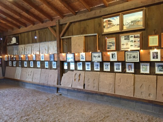
The Superstition Mountain Museum on the Apache Trail is where artifacts of the Lost Dutchmean are on display along with a museum of artifacts. Also in this location are the remnants of a retired movie set called Apacheland Movie Ranch. Apacheland Movie Ranch, which opened in 1960, was where many western movies and television shows were filmed. An entire western set was built and used for such Westerns as Gunfight at the OK Corral, The Battle of Cable Hogue, Lust for Gold, North of the Rio Grande, Mountain Road, A Time for Dying, Blind Justice, The Gambler II, The Highwayman, How the West Was Won, and Elvis’ Charro. Some of the television series that were filmed there are Death Valley Days, Have Gun Will Travel, Stagecoach, and The Rifleman. These are just a few of the movies and television series filmed here. There were so MANY familiar names and faces of actors and actresses who were filmed at Apacheland on these walls. You might be able to zoom in to see some of their faces and names better. Those squares below the photos are some of their foot prints and signatures in concrete.


The church used in the movie Charro starring Elvis Presley. This church was also used in numerous western movies and television shows.

Display of Apacheland Movie Ranch photos inside the church.

Elvis WAS in the building (church)!
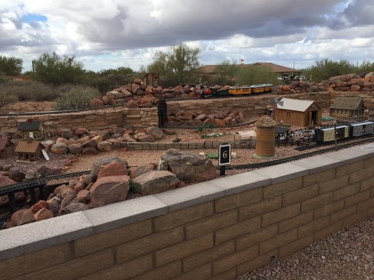
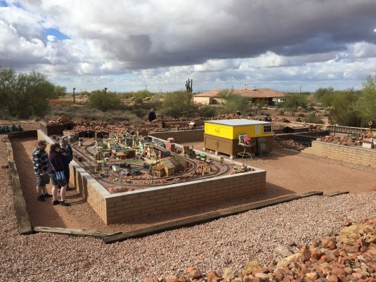
Behind the Superstition Mountain Museum is the Superstition Mountain Museum Railroad – Dutchman’s Gulch. This is a unique Garden-scaled model train exhibit designed to delight model train enthusiasts and make learning history fun for all. This exhibit portrays the building of the railroad in this area from the early 1500s to 1864 and forward. This exhibit has been made possible by donations of engines, train cars, tracks, model buildings, and money along with countless volunteer work hours by many people during construction. Those volunteers still work on the display frequently making repairs and upgrades.


After we left Superstition Mountain, we took Highway 88 to Canyon Lake and Tortilla Flat. The drive was up and down steep mountainsides on a narrow, very curvy two lane road. However, it was absolutely breathtaking as the sun began to peak out from the clouds. We got our first glimpse of Canyon Lake from high up on a mountainside at a lookout point. It was gorgeous!


Can you see the speed boat in the photo?


As we continued to Tortilla Flat, we were pretty much traveling downhill all the way to the lake. There were several one lane bridges along the way as well as several different camping areas right next to the lake. A close up look at Canyon Lake revealed just how beautiful it is!


This is one of the old, one lane bridges we had to cross.

This would be a GORGEOUS place to camp!


Tortilla Flat got it’s start because of road construction to Roosevelt Dam in 1904. There was a need for a stagecoach stop for freight haulers on their way to the construction site, so Tortilla Flat served that purpose. After that it became a stage stop for tourists and mail carriers. Tortilla Flat is a very small town consisting of a U.S. Post Office and voter’s precinct, and it only has a population of SIX! It is basically one street that still resembles an old west town. There is a restaurant, saloon, gift shop (a.k.a. tourist trap!), an ice cream/fudge shop with groceries, and a post office. There is NO motel! It was fun to browse the stores and eat some ice cream.


I guess this “dummie” was caught shoplifting. 😂

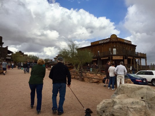
After spending some time in Tortilla Flat, we headed back the way we came on Highway 88 toward Apache Junction. We had passed Goldfield (Ghost Town) and wanted to stop there before heading home.
Goldfield was the site of Mammoth Gold Mine and during the 1890s was a bustling town with three saloons, a boarding house, general store, blacksmith shop, brewery, meat market, and school house. Just when it looked like Goldfield was going to outgrow Mesa, AZ, the mine failed when the grade of ore dropped dramatically. Unfortunately the town died a slow, painful death.
Now Goldfield is a wonderful place to visit and learn more about the history of the area. You can walk down Main Street and explore the shops and historic buildings. You can also take a tour of the mine and actually pan for gold (neither of which we did 😢). If you panned for gold, you got to KEEP any gold you might find (usually just slivers of gold).
We just took a brief look through the town because the weather had gotten cloudy, cold, and windy while we were there. We were even rained on a couple of times. The first downpour started suddenly and was very cold rain, so everyone ran for cover. I started towards the saloon, and Jack was headed towards the … wait for it … Bordello! 😂🤣😂🤣 I had to grab him quickly and head back towards the saloon. Here are a few pics of the town and some of the historic buildings.


The Bordello was on the top floor of this interesting looking building.


We had a wonderful day exploring the beautiful landscape, learning more about the history of the area, and spending time with great friends!
So for now ….. “On the Road Again!”
Betty