
March 6th Jack, Zoey, and I headed north for our first ever visit to the Grand Canyon. We had originally planned to stay in Williams, AZ, and take the Grand Canyon Railway scenic train ride to Grand Canyon Village. When I called to make the reservations, I was informed that dogs cannot ride on the train (not even in an enclosed carrier), so we had to change our plans. We did, however, stop in Williams on our way to the Grand Canyon to eat, shop (of course!), and explore a little.

As with all our trips, the scenery was beautiful as we traveled to the Grand Canyon.

These mountains are known as the San Francisco Peaks, a group of dormant volcanic peaks. They are about 11 miles north of Flagstaff in the Coconino National Forest. Humphreys Peak is the highest peak in the group and the highest point in the state of Arizona with an elevation of 12,633 feet.


Williams, which was settled in 1881, now has a population of about 3,000. It is west of Flagstaff on I 40 and lies on Historic Route 66. The Historic Downtown District is six square blocks and boasts a rich heritage that features the Old West, Route 66, and tourism. Williams was the LAST town in the country to have its part of Route 66 bypassed because of lawsuits that kept the last section of I 40 from being built around the town. The lawsuits were settled and I 40 was completed when the state agreed to build three Williams exits. On October 13, 1984, Interstate 40 was opened and newspapers around the country reported the end of US 66. Route 66 was decommissioned in 1985.
Like so many of the “western” small towns that we visited in Arizona, Williams has a lot of historic buildings and interesting things to see.


One of the trains of the Grand Canyon Railway waiting to take passengers to the Grand Canyon.
We arrived at our hotel, the Red Feather Lodge, in Tusayan, AZ, around 4:00 p.m. We checked in and got settled quickly because we wanted to hurry up to the Grand Canyon to try to catch the sun setting. Our hotel was one mile from the entrance to the park.

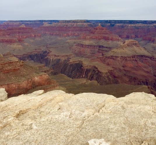
From the entrance, it was about a 10-15 drive to the nearest edge of the canyon at Mather Point. By the time we got there, found a place to park, and walked to the Visitors Center, the center was closed. Some nice people gave us directions to Mather Point and the view was fantastic. I took WAY TOO MANY pictures, and I’m sure they all look alike. However, the pictures just don’t do the grandeur of the view justice. Here are some views from and around Mather Point:


This is Mather Point (I think 😆; I forget after a couple of days!). It does have a railing, and we did walk out on it. For us: NO railing = NOT walking out on it!!


We still had a little time before the actual sunset, so we drove to Grand Canyon Village which has several (4-5) resorts/lodges and the depot for the Grand Canyon Railway. This was a much smaller area than I expected considering all the lodging that was there. There just wasn’t anywhere to park unless you were registered at one of the hotels. Jack graciously let me out of the car so I could take some pictures of the sunset while he and Zoey just kind of drove around. These pictures were taken from the Grand Canyon Village area during sunset:


We went back to our hotel, ate some supper, and rested up for the next day of hiking the southern rim of the Grand Canyon. When we woke up the next morning it was overcast. Unfortunately it was overcast all day, so my pictures aren’t probably as colorful as they would have been on a bright, sunny day. Oh, well, that’s life.
Thise next day we visited and hiked the area around the Geological Museum. Then we took Highway 64 east to Desert View Watch Tower. There were several scenic “pull over and stop” places as well as at least 4 major lookout points (Yaki Point [which was closed to the public], Grandview Point, Moran Point, Lipan Point [our FAVORITE!], and Navajo Point), along the 22 mile road to Desert View Watch Tower. Here are a few photos of the area west and east of the Geological Museum (you can tell it was a cloudy day).


The next day we were heading back to Buckeye and the RV. When we woke up and looked outside, the sun was SHINING! We decided we would take the drive to Desert View Watch Tower again to get some photos of some of the same places with more sunlight. I won’t bore you with all the “cloudy/overcast” pictures; I’ll just post the sunny day pictures because they are much prettier:


This is Duck on a Rock (you have to use your imagination to “see” the duck).

This is the Colorado River which helped to carve out the Grand Canyon. Look on the left about half way down from the top, and you’ll see a black bird sitting on the top of a tree.


You can see Hance Rapid in the top third of this picture and slightly left of center. Read the information about the rapids in the photo above this one. It’s hard to believe those rapids are 3.8 MILES away from where I was standing! The next photo is also of Hance Rapid but I zoomed in as far as my iPhone would let me.


This is Desert View Watch Tower as we were walking towards it from the parking lot. The following photos are from this viewing point.


Desert View Watch Tower is the area of the Grand Canyon where a tragic mid-air collision of two aircrafts occurred in 1956. Here is a photo of the plaque commemorating the accident and the lives lost, and a photo telling about it and pointing out where the wreckage was found (you’ll have to try to zoom in to read some of it).


After viewing the Grand Canyon for the last time, we continued on state highway 64 to Cameron, AZ. We then took highway 89 south to Flagstaff and then took Interstate 17 south. We had heard a lot about the town of Prescott, AZ, so we decided to take a little detour to check it out. The whole Prescott Valley is beautiful and has just about anything and everything a person could desire (stores, shopping, restaurants, etc., etc.). Believe me, it is a very busy place with a lot of people.
Prescott, AZ, has a population of almost 40,000 and is the county seat of Yavapai County. It was named after William H. Prescott, a writer who was popular during the Civial War. In 1864 Prescott was named the capital of the Arizona Territory until it was moved to Tucson in 1867; it was moved back to Prescott a few years later until Phoenix became the capital in 1889 (since I taught states and capitals to 5th graders for many years, capitals are of great interest to me).
MORE INTERESTING TIDBITS ABOUT PRESCOTT:
Prescott is home to Arizona Pioneers’ Home and Hospital for Disabled Miners which opened February 1, 1911 (there were A LOT of mines in Arizona during the late 1800s and early 1900s).
Since my husband is all about everything COWBOY, here’s an interesting tidbit about Prescott: In 1879 Virgil Earp, Wyatt Earp’s older brother, lived in Prescott. Virgil told Wyatt of the boom town in Tombstone, Arizona (you know – the gunfight at the OK Corral). There are also rumors that Doc Holliday spent some time in Prescott before heading to Tombstone.
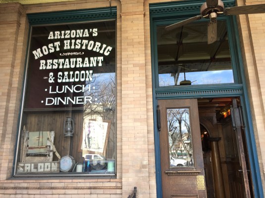
Whiskey Row in downtown Prescott boasts many historic buildings, including The Palace, Arizona’s oldest restaurant and bar. The Palace is still the oldest frontier saloon in Arizona, and, of course, we had to eat there.
Barry Goldwater launched his presidential campaign from the steps of Prescott’s Yavapai County Courthhouse in 1964.
Here are some photos of historic downtown Prescott including some of The Palace where we ate a late lunch.


The stairs going up to the bordello.
The next photos show some historical artifacts in display cases inside The Palace.


After eating a late lunch at The Palace on Thursday, March 8, we headed back to Buckeye. We had a wonderful visit to the Grand Canyon and fun seeing historic downtown Prescott.
After our trip we had about a week left in Buckeye, AZ. We will be getting things clean, organized, and packed up to leave here and head to our next destination.
So, for now ….. “On the Road Again!”
Betty
Mar 16, 2018 @ 10:27:15
Your pictures of the Grand Canyon are just stunning Betty, I truly hope I can get Ed out there sometime. Your visit there sounds wonderful. I’m so glad that you are enjoying your nomadic life and seeing our country in all its splendor. Love both you and Jack
Mar 16, 2018 @ 21:20:54
Thanks, Peg! My pictures are all taken with my iPhone 6 (it doesn’t do too bad) because my laptop isn’t allowing my to upload pics taken with my good Sony camera. When I get back to STL, maybe I can get Jared or someone to help me figure out why it’s not giving me the upload pics option. Love you all, too! ❤️ 😘 💋
Mar 17, 2018 @ 03:56:30
Thanks for a great walk down memory lane. Tim and I stayed in Williams last summer and took our motorcycle to the Grand Canyon and traveled many of the identical locations you all visited…! A beautiful part of our country…!
Mar 17, 2018 @ 16:54:57
Thanks, Kathy. It amazes me how one can spend hours and hours gazing at all the glorious beauty in and surrounding that canyon.