
Yesterday we took the whole day and visited Joshua Tree National Park. This park has the distinction of being known as the place where two very different desert ecosystems come together: the Mohave Desert and the Colorado Desert. These two desert ecosystems are primarily determined by elevation.
The higher (3,000 feet and more elevation) and cooler Mohave Desert’s habitat is where you’ll find the Joshua tree (Yucca brevifolia) for which the park is named. In some places of the park, the Joshua trees are sparse, and other places are filled with dense forests of the them. The Joshua trees dominate the open spaces of the park, however, you will also see other varieties of trees and shrubs (California junipers, desert scrub oak, and others).
Below the elevation of 3,000 feet and in the eastern part of the park is where you will find the Colorado desert. There you will find Creosote bush scrub, Ocotilla, desert Saltbush, Yucca, and Cholla cactus (all of which we saw plenty of as we drove by the east side of the park the day we traveled from Buckeye, AZ to Twentynine Palms, CA).
There is an area on the eastern side of the park where the Mojave and Colorado Deserts “merge” together in what they call the transition zone. There one will find an ecological melting pot. The transition zone is where the Mojave and Colorado deserts blend together featuring plants and animals representative of both. This area is VERY remote and is only accessible by permit and hiking in to it. Because of those conditions, we did not visit there.
The terrain in the park is so varied: steep and rocky mountains, valleys, and fascinating rock formations. We stopped at many roadside viewing places as well as many points of interest listed on the park map. To say the park is beautiful is an understatement. I’ll just let the pictures say it all. If there is a caption with the picture, it will tell you what point of interest we were at. No caption means I thought it was just a pretty view.


It does kind of look like a skull. It also reminds me of the Conehead skits on Saturday Night Live back in 1970s. 😆


These rocks look smooth, but don’t let them fool you.

Can you see the “rainbow” phenomena just above the rock on the left? I tried a google search to learn what it was, but I’m not sure that what I found is correct. It might be part of an arc or halo.


This is a close up of those “smooth” looking rocks.

This is one of the fuller, prettier Joshua trees we saw. Google this tree and read about how long it takes for them to grow. It is fascinating.

This is near Sheep pass. Joshua Tree Park is home to about 300 Desert Bighorn Sheep. We didn’t see any though. 😔


Can you see the huge rock at the top, to the left of the middle? Many of these rocks are precariously perched on other rocks and look as if they could be pushed off with little effort which, I’m sure, is not true.


Look at that tree! I have no idea how it continues to live and grow.


The next six photos are taken at Keys View (elevation: 5,185 feet) in the southwest area of the park. You can zoom in on this picture of information to read about the things that one can see from the top of this mountain. Then look closely at my photos and see if you can identify any of the places mentioned on this plaque. Refer back to this photo if necessary.

Do you remember in my recent post about going to Desert Palm and Palm Springs that I mentioned seeing fields and fields of wind turbines? Well, you can actually see those fields of turbines from atop this mountain. They don’t show up too good in this photo (zoom in to the whitish area in the middle of the photo and about a third of the way down from the top. You could see the turbines pretty easily in person!


Below the snow covered peaks in the middle of the picture is Palm Springs, CA.
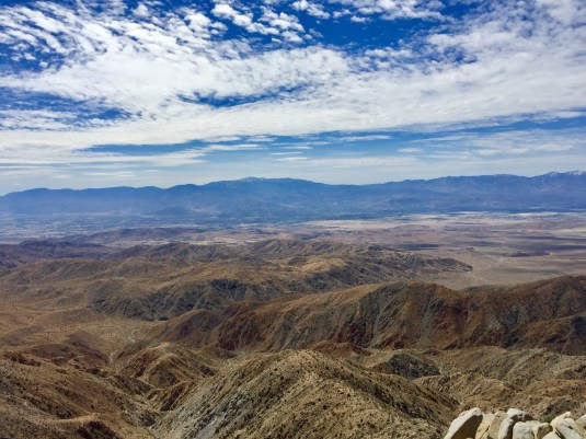

Desert Palm, CA, is located near the middle of this picture.

Look right above the mountaintops in the middle of this picture. Look closely at the horizon and you will see a body of water. That is the Salton Sea which is 235 feet below sea level and 35 miles away from our position. If you zoom in and look VERY closely, you might be able to see Signal Mountain which is 95 miles away near the U.S.-Mexican border!


Along one of the “forests” of Joshua trees.


Here is another one of those precariously perched boulders that looks as if it could fall right off at any minute. I’m not sure I would want to be camping right below that thing.


A selfie at the top at Keys View with Palm Springs in the background.
While we were at the Joshua Tree National Park Visitor Center, I bought a National Park Passport book. This book lists all the national parks, national historic sites, and national memorials in the United States. It is set up by regions and gives you a checklist of parks in that area. You can also purchase a sticker at each park to put in your book. Also, if you have your book with you, you can have your book stamped by a National Park Service Agent (just like you get your real U.S. passport stamped when you visit another country). Now I just need to figure out how to get the stickers for the parks we have already visited!


I had my new passport book stamped and bought my sticker for Joshua Tree National Park.
Our next major short trip will be into Los Angeles! We leave on Sunday, but you can start praying for our safety now because we will be navigating through the LA traffic! 😝 We are NOT driving the RV into LA though; we are leaving it at the RV park and just driving our Honda CR-V and staying in a hotel for a couple of nights. However, we could still use prayers for safety in THAT traffic!
So for now ….. “On the Road Again!”
Betty