
NOTE: Oh, my goodness! I’ve been having a little bit of trouble with not only cell tower service in northern Minnesota but also with my blog’s website and app (and maybe a little bit of trouble with my memory 😝). It wasn’t until today (Sept.13) that this draft showed up on my blog account website with a message that it had never been published! I am so sorry.
Soooooooo ….. this post should have been published some time around August 24th:
On August 5th we “pulled up stakes” and headed to our next destination. Can you guess where we were headed? I’ll give you a hint: a little farther north and west.


Yes. Duluth, Minnesota. We found a RV park a little northwest of downtown Duluth. It’s a nice park with several ponds, level sites, and some trees for shade but NOT too many trees. That means we can actually recieve our satellite signal! YEAH! We have been without satellite and the ability to record shows on the DVR since June 14. Thank goodness we have been in the rerun season! I know that sounds ”trivial” to some of you, however, when recording shows, we can watch them when we choose to watch around our ”site-seeing” and “eating out with new friends” schedule.
Lake Superior’s North Shore is full of wonderful and beautiful places to stop and explore. You can actually follow the North Shore on Highway 61 all the way to Canada (it’s about 200 miles, or a four hour drive, from Duluth to Thunder Bay, Ontario, Canada). We are not planning on going into Canada, but we did travel as far north as Silver Bay, MN, and Tettegouche State Park making several stops along the way.
First, we headed north on Interstate 35 out of downtown Duluth. After a short distance the interstate ends, and it changes to state Highway 61. We stopped at a Tourist Information Center where we got a map and several suggestions. We took the “scenic” route for Highway 61 as suggested which went right along the shore of Lake Superior. As always, the views of Lake Superior along this scenic route were spectacular.
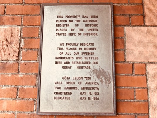
Our first stop was Two Harbors, MN, which was named after the two natural harbors located there: Burlington Bay and Agate Bay. Two Harbors was Minnesota’s first iron-ore port. It is also home to Two Harbors Light Station, Two Harbors Breakwater and Lighthouse, and the Edna G, an 1890s tugboat that retired in 1981. There is also a Museum in the old train station (now a museum) with old railcars from the Duluth & Iron Range and the Duluth Missabe & Iron Range railroads.


If you are ever in Two Harbors, you need to stop at Betty’s Pies and Rustic Inn. Both places are well known in the area for their delicious pies. They also serve sandwiches and meals, but you should be prepared for a LONG wait to be seated. We didn’t eat at either place; we got our pie to go. Both places had delicious pies, but my favorite was Rustic Inn and their French Apple pie. Jack’s was Betty’s Pies apple pie. I got a picture of Betty’s Pies, but I forgot to take one of Rustic Inn. Ooops! 😔

Next stop was Gooseberry Falls State Park. Countless numbers of streams drain into Lake Superior, however, none do so as dramatically as Gooseberry River. The Upper and Lower Falls plunge 30 and 60 feet, respectively. We hiked to the falls, but there is so much more to the state park.
There is around 1,700 acres with 18 miles of trails in Gooseberry Falls State Park. Gooseberry Falls is linked to six other state parks along the North Shore by the Superior Hiking Trail (a narrow 300 mile path that will parallel the entire length of Lake Superior’s rocky rim from Duluth to the Canadian border when completed). This trail will provide hikers with unique perspectives of the beauty to be found in the area. And ….. no, we did not hike that trail.


Looking down river after the falls towards Lake Superior.

This isn’t the best picture and it was hazy this day, but you could see Gooseberry River dumping into Lake Superior (I zoomed in and it doesn’t show up very well).
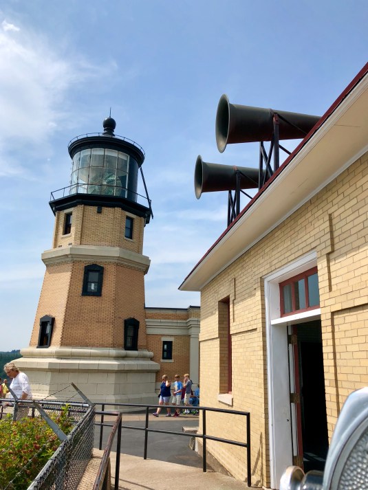
On to Split Rock Lighthouse State Park which is one of the North’s Shore’s most famous attractions. After NINE ships wrecked within 12 miles of the Split Rock River during a fierce storm in November 1905, the federal government commissioned a lighthouse to be built atop the 110-foot cliff that overlooked the disaster. Its powerful beam was visible from up to 20 miles away until 1969 when electronic navigational equipment rendered it obsolete.


On the way to Split Rock Lighthouse, there was a scenic overlook along the highway. This was the view of the lighthouse from there.

Same view only zoomed in some.

….. And zoomed in some more.

Right below the lighthouse, this little guy was having lunch.

I have no idea what kind of creature this is. Maybe you know. Leave me a comment.

The three lighthouse keepers houses.

There were three full time keepers for the lighthouse all the time. Someone was on duty 24 hours a day; 7 days a week.

Looking south from the lighthouse.

The fog horn building.

The lighthouse building.

Looking down the cliffs. Look at those huge boulders!

Look how clear the water is.

Zoom in to read some of the information about the nine ships that sank in this area in 1905.

Sorry about the glare on the information board. This was the best I could do.

Looking south.

Looking north.


This guy greeted me as I walked into the base of the lighthouse.

Some old equipment.

The stairs going up to the actual light.


At the top you see the actual light fixture…

…made in Paris…

…turning around…

…and around…

…and you can see the mirrors…

…with the light…

…AMAZING!! It is not a very big area up there and there were more people coming up…

…so I decided to go back down…

…Going down was scarier for me and not as easy as going up…

…But I did it!

This view is of the scenic overlook where we stopped to see the lighthouse from the highway. The arrow points to where I was standing when I took those pictures.
Here is a short video of the light going around. Unknown to me, three little boys were climbing up. Their reaction to the light fixture going around is PRICELESS! (I hope this video actually posts! If it doesn’t, I did something wrong. 😬 )
” ]Next, I toured one of the keepers houses. It was restored to it’s original decor from the early 1900s when it was built. After I toured the house, I walked down a path a little ways and took some more pictures of the lighthouse and scenery.

The first keepers house was the one we could tour. The second one is where the park manager lives. The third one has not been restored.

Living room.

Desk in dining room.

Dining room.

Pantry between kitchen and dining room.

Cabinet between kitchen and dining room.

Kitchen.

Kitchen.

Stairs going to second floor.

Hallway at the top of the stairs.

Bathroom. I have NO idea whose arm that is or how it got there! 😂 If I would have known that arm was there, I would have taken another picture!!

Bathroom. No arm in this picture!

Master bedroom.

Son’s bedroom.

Son’s room.

Daughter’s bedroom.

Daughter’s room

View from the front porch of the keeper’s house.

The path I walked down on the south side of the keepers houses.

View of the cliffs. Can you see the boulders under the water?

Looking back at the lighthouse…

…from the south side.

Another view along the path.

Again, more of the rocky shoreline.

Final view of the lighthouse and fog horn house as I left.
Palisade Head was the next and final stop on our agenda of stops. Palisade Head is some 350 feet high and marks the beginning of the Lake Superior palisades, a ragged wall that extends some 40 miles. Daring rock climbers like to creep across its sheer faces and kayakers enjoy paddling among the wind- and water-scoured caves below. For us, the views from the top were fantastic. Since we were standing on the top of Palisade Head, we could only enjoy the view. I guess we need to take a boat ride or kayak to see it from the water!


We drove a little further north to Tettegouche State Park. We stopped in the Visitors Center, but because it was getting late in the day, we didn’t explore the park. That may have to wait for another day trip. 😊
So for now ….. “On the Road Again!”
Betty